
Climate IntelligenceBeyond Data Streams

Real-time GOES satellite imagery, NEXRAD radar, NASA EONET disasters, NOAA GFS forecasts, and conversational AI powered by AWS Bedrock Claude Sonnet 4.5.

GOES-16/17/18/19 with 16 spectral bands and 160+ NEXRAD sites for real-time monitoring
NASA EONET tracking 12 disaster categories from wildfires to earthquakes with magnitude data
AWS Bedrock Claude Sonnet 4.5 conversational AI with RAG context from all 5 production data streams

Trusted by federal agencies, research institutions, and enterprise organizations

EARTH
REAL-TIME
GOES-R ABI
NEXRAD Level III
NASA EONET
OpenWeather
GFS 0.25°
5
Production Streams
16
GOES Bands
160+
NEXRAD Sites
12
Disaster Types
GOES-R
NEXRAD
EONET
OpenWeather
GFS 0.25°

Why Climate Intelligence Matters Now

Climate risk is mission-critical. Data is overwhelming. Organizations need integrated tools to make sense of the chaos.

Unworkable

Current tools are fragmented across multiple platforms—users need 5+ subscriptions to access satellite, radar, and disaster data. EarthOptix unifies GOES-R, NEXRAD, EONET, GFS, and OpenWeather in one interface with conversational AI.

Urgent

Extreme weather losses escalating into hundreds of billions annually. NASA EONET tracks 12 disaster categories in real-time (wildfires, floods, storms) with 15-minute polling—enabling proactive response instead of reactive cleanup.

Underserved

Many organizations lack access to enterprise-grade climate intelligence. EarthOptix democratizes expert analysis through AWS Bedrock Claude Sonnet 4.5—conversational meteorologist for $149/month instead of $150K/year expert.

Unavoidable

Regulatory mandates (SEC climate disclosure, net-zero reporting) force adoption. EarthOptix FedRAMP-aligned architecture with audit-grade data lineage ensures compliance-ready intelligence for government and enterprise.

Platform Advantages

Three core capabilities that transform climate data into actionable intelligence for enterprise and government operations.

Real-Time Data Fusion

Ingest, Harmonize, and Fuse Multi-Source Climate Data

Continuously ingests and harmonizes live feeds from GOES-R satellites, NEXRAD radar network, NASA EONET disasters, NOAA GFS forecasts, and OpenWeather—built on AWS‑native, event‑driven pipelines for sub-minute awareness across 5 production data streams.

  • NOAA GFS 0.25°: 384-Hour Global Forecasts
    24+ variables, 4 daily cycles, COG tile server with sub-second delivery
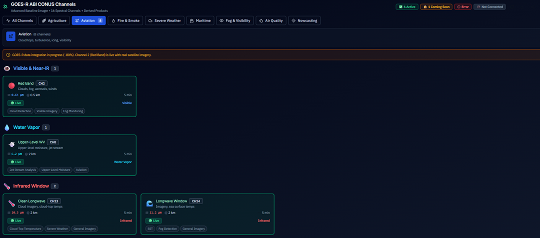
  • GOES-16/17/18/19: 16 Spectral Bands
    Real-time satellite imagery with fire detection (Band 7), water vapor, and IR channels
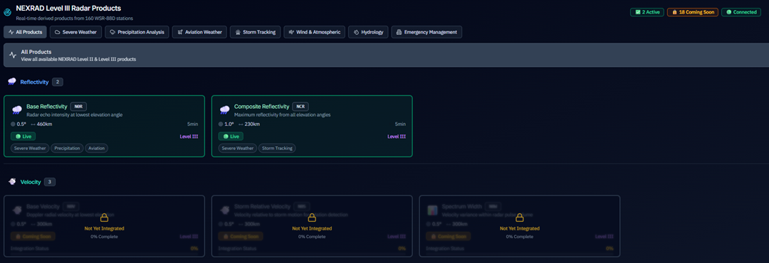
  • NEXRAD Level III: 160+ Radar Sites
    Composite reflectivity, base products, velocity analysis for severe weather tracking
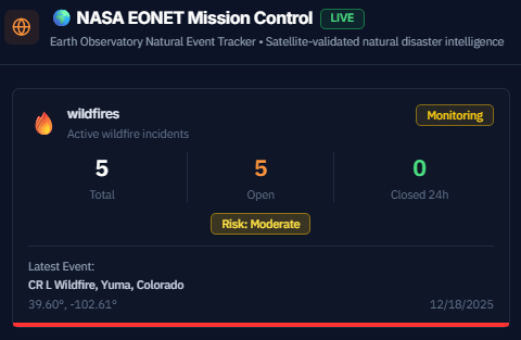
  • NASA EONET: 12 Disaster Categories
    Wildfires, floods, storms, earthquakes with magnitude tracking and 15-min polling
  • OpenWeather: Real-Time City Conditions
    10-minute refresh intervals with GPS-based location awareness

Outcome: First platform to overlay NASA EONET wildfire events on GOES Band 7 fire detection imagery with GFS wind forecasts—enabling multi-source fusion that no competitor offers.

EarthOptix Platform Dashboard - Real-time multi-stream climate intelligence with GOES-R, NEXRAD, EONET, GFS, and OpenWeather data fusion
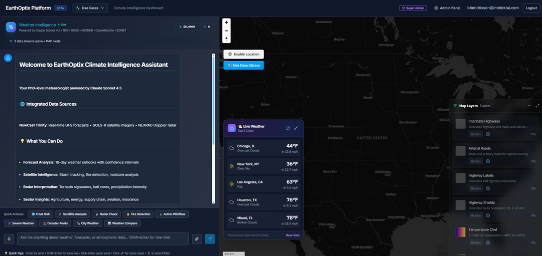
Platform Live • 5 Streams Operational
AI Model
Claude 4.5
Trial Period
Included Credits
Explore all capabilities
Data Sources
5 Streams
AI-Driven Analytics

Convert Geospatial Complexity into Clear, Defensible Answers

AWS Bedrock Claude Sonnet 4.5 with RAG (Retrieval Augmented Generation) architecture automatically injects context from all 5 data streams—converting multi-source geospatial complexity into conversational intelligence with full provenance and audit trails.

  • AWS Bedrock Claude Sonnet 4.5
    Production-deployed with $25 free tier and per-query cost tracking
  • RAG with Multi-Source Context
    Automatic context injection from GFS, GOES, NEXRAD, EONET, and OpenWeather
  • Voice Input & Code Syntax Highlighting
    Web Speech API integration with markdown rendering and multi-language code support
  • Natural Language Queries
    "Show me wildfires near severe storms" with Quick Actions for common workflows

Outcome: First conversational meteorologist that costs $149/month instead of $150K/year—no competitor offers LLM-powered weather analysis with multi-source RAG context.

Government-Grade Security

FedRAMP-Aligned Architecture with Zero-Trust Patterns

Built for regulated deployments from day one with FedRAMP Moderate posture, zero-trust architecture, and strict multi-tenant isolation—ensuring enterprise and government organizations can trust EarthOptix with mission-critical workloads.

  • FedRAMP Moderate Posture
    FIPS 140-2 encryption with continuous compliance monitoring
  • Multi-Tenant Isolation
    Silo, bridge, and pool models with strict IAM boundaries
  • Continuous Audit Trails
    CloudTrail, GuardDuty, and Security Hub integration
  • Zero Vendor Lock-In
    AWS-native but portable architecture with open standards

Outcome: Enterprise and government confidence to run mission-critical climate workloads on EarthOptix with full regulatory compliance and data sovereignty.

Compliance LevelFedRAMP
EncryptionFIPS 140-2
Uptime SLA99.99%
Production Data Streams

5 Operational Data Streams

Real-time multi-sensor fusion from NOAA, NASA, and authoritative sources—powering the first conversational climate intelligence platform with sub-second delivery and enterprise-grade reliability.

16
GOES Bands
160+
NEXRAD Sites
12
Disaster Types
24+
GFS Variables
15min
EONET Polling
Primary

GOES-R ABI CONUS

NOAA GOES-16/17/18/19 Satellites

Spectral Bands
16
Satellites
4 Active
Resolution
500m-2km
Coverage
Hemisphere
Update FrequencyReal-time

Capabilities

  • Band 2: Red Visible (0.64 μm) — Daytime cloud imagery
  • Band 7: Shortwave IR (3.9 μm) — Active fire detection
  • Band 8-10: Water vapor channels — Storm development tracking
  • Band 13: Clean IR (10.3 μm) — 24/7 cloud monitoring
  • Band 14: IR Window (11.2 μm) — Sea surface temperature, fog detection
  • Mission control panel with use-case filters (Agriculture, Aviation, Fire, Marine)
Primary

NEXRAD Level III

NOAA WSR-88D Radar Network

Radar Sites
160+
Coverage
CONUS
Resolution
250m-1km
Products
20+ Types
Update Frequency5-10 min

Capabilities

  • Composite reflectivity (NCR) — National precipitation intensity
  • Base reflectivity (N0Q, N0R, N0S, N0Z) — Local storm structure
  • Velocity products — Wind analysis and rotation detection
  • Use-case filtering: Severe Weather, Aviation, Flooding, Winter Weather
  • Real-time MapLibre tile layer integration
  • Site-specific product selection with mission control panel
Primary

NASA EONET

Earth Observatory Natural Event Tracker

Categories
12
Polling
15 min
Storage
DynamoDB
Indexes
3 GSIs
Update Frequency15 min

Capabilities

  • Wildfires, floods, severe storms, volcanoes, earthquakes
  • Sea/lake ice, snow, drought, dust/haze, landslides
  • Manmade events, water color anomalies
  • Magnitude data capture with standardized units
  • Geographic bounding box filtering (configurable regions)
  • SNS proximity alerts (50km radius)
  • S3 archival with Intelligent-Tiering
Supporting

NOAA GFS 0.25°

Global Forecast System

Variables
24+
Cycles/Day
4
Forecast
384 hours
Resolution
0.25°
Update Frequency6 hours

Capabilities

  • Temperature, humidity, wind speed/direction, precipitation
  • Pressure, cloud cover, dew point, visibility
  • COG (Cloud Optimized GeoTIFF) tile server
  • WebMercatorQuad projection for MapLibre integration
  • 6-hourly model cycles (00Z, 06Z, 12Z, 18Z)
  • AWS S3 direct access with CloudFront CDN delivery
Supporting

OpenWeather

OpenWeather API

Cities
Major US
Metrics
8+
Location
GPS/IP
Widget
Min/Max
Update Frequency10 min

Capabilities

  • Current weather for major US cities (Chicago, NYC, LA, Houston, Miami)
  • User location-based weather via GPS or CloudFront approximation
  • Temperature, feels-like, humidity, wind speed/direction
  • Visibility, pressure, weather description with icons
  • Minimizable/maximizable weather widget
  • Auto-refresh every 10 minutes

AWS-Native Architecture

Data Pipeline

  • EventBridge scheduled ingestion (15-min to 6-hour intervals)
  • Lambda processing with Node.js 20 runtime
  • DynamoDB for event storage with 3 GSI indexes
  • S3 archival with Intelligent-Tiering cost optimization

Delivery & Security

  • CloudFront CDN for sub-second tile delivery
  • MapLibre GL JS real-time visualization
  • AWS WAF rate limiting and DDoS protection
  • Cognito authentication with API Gateway Lambda authorizers

Platform in Action

Real screenshots from the EarthOptix platform—showing operational data streams, live visualizations, and multi-source fusion capabilities.

EarthOptix Platform - NASA EONET disaster tracking with 12 categories including wildfires, floods, and storms

NASA EONET

Real-time disaster tracking with 15-minute polling across 12 event categories

EarthOptix Platform - GOES-R satellite imagery with 16 spectral bands for fire detection and weather monitoring

GOES-R ABI

16 spectral bands from 4 satellites including Band 7 fire detection

EarthOptix Platform - NEXRAD Level III radar with 160+ WSR-88D sites for severe weather tracking

NEXRAD Level III

160+ radar sites with composite reflectivity and velocity products

Platform Roadmap

Strategic Expansion: Phase 1 Complete

Through rigorous research and evaluation, EarthOptix has identified 17 authoritative data streams for integration. 4 streams are now operational, with enterprise-grade pipelines proven at scale.

Strategic Data Streams4 of 17 Operational
23% Complete

Currently Operational (Phase 1)

NOAA GFS
Global Forecast System 0.25°
NOAA NEXRAD
WSR-88D Radar Network
NOAA GOES-R
Geostationary Satellites (16/17/18/19)
NOAA Emergency Response
Disaster Imagery & Analytics

Expansion Pipeline: 13 Additional Streams Across 10 Categories

1
NOAA Weather
2
NASA Earth Obs
3
Space Weather
4
European Data
5
Land & Water
6
Air Quality
7
Disaster Tracking
8
Agriculture
9
Infrastructure
10
HPC Research

Cloud-native architecture enables rapid expansion. Future streams include USGS Landsat, ESA Sentinel-2, MODIS, VIIRS, NASA NEX climate projections, CMIP6 models, air quality forecasts, oceanographic data, and socioeconomic layers—delivering comprehensive environmental intelligence across government, energy, agriculture, and logistics sectors.

Simple, Transparent Pricing

Choose the plan that fits your organization. All plans include access to authoritative data from NASA, NOAA, ESA, and USGS.

Essential

Core climate data for small teams

$299/month
  • NOAA GFS weather forecasts
  • Basic API access
  • Email support
  • 10 API calls/second
  • Standard data refresh
Get Started
Most Popular

Professional

Multi-stream intelligence for enterprises

$999/month
  • All Essential features
  • 5 additional data streams (NEXRAD, GOES, etc.)
  • Priority support
  • 100 API calls/second
  • Custom data pipelines
  • FedRAMP compliance ready
Get Started

Enterprise

Full platform access with dedicated support

$2,999/month
  • All Professional features
  • 17+ authoritative data streams
  • Dedicated account manager
  • Unlimited API calls
  • Custom HPC workloads
  • LLM-driven insights
  • SLA guarantees
Get Started

Platform Value

$772M

Annual U.S. benefits from NOAA data alone

17+

Authoritative data streams

<60 min

Data fusion vs. 8-12 weeks manual

99.9%

Uptime SLA on AWS infrastructure

Ready to Transform Climate Intelligence?

Join enterprise, government, and research institutions leveraging EarthOptix for mission-critical climate decisions

Access Platform Now

No credit card required • FedRAMP Ready • 48-hour implementation